Home
Create Account Sign In
Engage
Contact Us
Search

Main Menu

  • Services for
    Residents
    • Connect with your City
      • Engage with your City
      • Request Services Online
      • Contact Us on our Website
      • Contact Us on Social Media
      • Contact Us by Phone
      • Organizational Charts
      • Free public WiFi pilot project
      • News Subscriptions
      • Open Data
    • Housing & Property
      • City-Owned Trees
        • Request a Tree
        • Tree Maintenance & Inspections
        • Tree Protection Requirements
          • Tree Permits
          • Tree Protection FAQs
        • Tree Diseases & Pests
          • Dutch Elm Disease
        • Tree Care
        • Industrial Tree Planting
      • Boarders
      • Yard & Garden
        • Yard & Garden Pests
          • Insect Biocontrols
          • Mosquito Counts
        • Public Space Gardening
        • Garage and Yard Sales
        • Recreation Vehicles
        • Residential Fences
        • Property Maintenance & Waste Management Appeals
        • Weed Control
        • Be Pesticide Free
        • Healthy Yards
      • Graffiti Reduction
      • Attainable Housing
        • Attainable Housing Program and Resources
        • Affordable Housing Incentives
        • Rapid Housing Initiative
      • Point-in-Time Count
      • Good Neighbour Guide
    • Property Tax & Assessment
      • Assessment Appeals
      • Assessment
      • Property Tax
        • Property Assessment & Tax Tool
          • Terms of Use
        • 2025 Property Tax Estimator
      • Tax Payment
        • Seniors Property Tax Deferral Program
        • Tax Instalment Payment Plan Service (TIPPS)
      • Request For Information
      • Tax Rates & Mill Rates
        • Municipal Tax Ratio Policy
    • Homebuilding, Renovations & Improvements
      • Getting Started
        • Building Permits
        • Building Permit Fees
        • Building Permit Timelines
        • Bylaws and Policies
      • Project Guides
        • Decks
        • Garages
        • Home Renovation, Addition or New Construction
        • Demolition
        • Secondary Suites
          • Legalizing Existing Suites
        • Garden and Garage Suites
        • Swimming Pools
      • Zoning
      • Permit Forms & Applications
      • Building Permit Inspections
      • Building & Property Information
        • Civic Addressing
        • Permit Data & Reports
      • 2020 National Codes
      • Renovation Resources
    • Power, Water & Sewer
      • My Utility Account
        • Payment Information
        • Connect or Disconnect Service
        • Reading Your Meter
          • Submit Your Meter Reading Online
        • eBill Signup
          • Switch to eBill!
        • Account Summary
        • Bill History
        • Consumption & Charges
        • Equalized Payment Plan
        • Payments & Credits
        • My Carts
        • Waste Utility Subsidy
      • Utility Rates
        • Electrical Rates
          • Electric Heat Relief Rebate
        • Waste Rates
        • Water Rates
      • SmartUTIL
      • Drinking Water
        • Drinking Water Advisories
          • DWA Dashboard
        • Water Quality Characteristics
        • Water Treatment Plant
        • Cross Connection Control
          • Cross Connection Prevention
        • Be Water Wise
        • Licensed Backflow Testers
        • Water Meters
          • Water Meter - AMI Project
          • Water Meter Updates
        • Water Workers Week
        • Lead Water Pipes
        • Water Main Breaks & Repairs
          • Water Main Replacement Program
        • Water & Wastewater Utility Rates
        • Your Water Meter
        • Frozen Pipes
        • Water Service for Businesses
      • Saskatoon Light & Power
        • Customer Care
          • Your Meter
        • Outages & Safety
          • Outages
          • Electrical Safety
        • Street Lighting
        • Services & Projects
          • Underground Line Locates
          • New or Upgraded Electrical Service
          • School Tours
          • Tree Trimming
          • Work With Us
        • Sustainable Electricity
          • Landfill Gas Collection & Power Generation System
          • Customer Self-Generation Programs
          • Dundonald Avenue Solar Farm
          • Solar Power Demonstration Site
        • About Us
      • Wastewater
        • Lift Stations
        • Sanitary Sewer
          • Sewer Use Bylaw
          • Sewer Backup
        • Wastewater Treatment Plant
          • Nutrient Recovery Facility
          • Digester & Heating Upgrades
        • Waste Hauler Disposal Facilities
        • Biosolids Pipeline Corridor Project
        • Prevent Irritable Sewer Syndrome
      • Locating an Underground Utility Line
      • Storm Water
        • Storm Water System
          • Ditch Crossings and Culvert Guidelines
          • Invasive Species
          • Storm Ponds
          • Yellow Fish Road
          • Storm Water and Flood Protection Charges
        • Flood Control Strategy
          • 24th Street Storm Sewer Project
          • USask Dry Storm Pond
        • Home Flood Protection
          • Protective Plumbing
          • Spring Snowmelt
        • Storm Water Credit Program
        • Storm Water Management Utility Exemption
      • Landlord-Tenant Agreement
    • Waste & Recycling
      • Collection Calendar
      • Garbage
        • Curbside Garbage (Black Cart)
        • Multi-Unit Garbage
        • Material Recovery Centre & Landfill
      • Recycling
        • Curbside Recycling
        • Multi-Unit Recycling
        • Recycling Depots
        • Household Glass Program
        • Business Recycling
        • Recycling Education
      • Organics (Food & Yard Waste)
        • Green Cart Program
        • Compost Depot
        • Home Composting
        • Christmas Tree Composting
        • Business Organic Waste
        • Multi Unit Organics
        • Organics Education
        • Organics Processing Facility
      • Waste Wizard
        • BizWiz
      • Cart Care
      • Household Hazardous Waste
      • Illegal Dumping
      • Community Programs
        • Assisted Waste Collections
        • Curbside Swap
          • List Your Curbside Swap
          • View Curbside Listings
        • Newcomer and EAL Recycling and Composting Workshops
        • School Education
        • Waste Reduction Wagon
      • Waste Reduction & Diversion
    • Fire & Emergency
      • About SFD
        • Fire Stations
          • Regional Training Facility
          • Relocating Fire Station No. 5: Improving Community Response
        • Master Plan
        • SFD Strategic Plan
        • Year in Review
      • Education & Awareness
        • Life/Fire Safety Education
          • Carbon Monoxide
          • Cooking Safety
          • Emergency Vehicles & Rules of the Road
          • Shelter Spaces
          • Encampments
          • Fire Extinguishers
          • Fire Hydrants
          • Fire Pits
          • Fireworks
          • Home Escape Plan
          • Lithium-Ion Batteries
          • Needles & Sharps
          • Outdoor Grilling Safety
          • River & Water Safety
          • Shelter in Place
          • Smoke Alarms
          • Smoking Materials
        • Safety & Prevention Programs
          • Steps to Safety
          • Steps to Safety Training
      • Response & Recovery
        • Emergency Rescue Operations
        • Fire Recovery & Support
      • Inspections & Investigations
        • Fire Inspections
        • Fire Investigations
        • Plan Reviews
        • Permits
      • Emergency Management
        • notifynow
        • Emergency Preparedness
        • Extreme Cold Weather Emergency Response Plan
        • Extreme Heat
        • Report a Spill
        • Command 9: Mobile Command Unit
        • Emergency Phone Numbers
      • Fire Community Support
      • Event & Presentation Requests
      • Recruitment
        • Firefighter-Paramedic Recruitment Roadmap
        • Firefighter Candidate Information Session
      • News & Information
    • Pet Licensing & Animal Services
      • Pet Licensing
        • Pet License Vendors
      • Subsidized Spay & Neuter Program
      • Dog Parks
        • Behaviour Awareness Training Sessions
        • Commercial Dog Walker
        • Dog Day of Summer
      • Enforcement
        • Paying your Animal Control Notice of Violation
        • Dangerous Animals
        • Reporting Nuisance Barking or Howling
        • Reporting an Animal at Large
      • Bite Prevention
      • Community Cats
      • Wildlife Management
        • Coyotes
      • Injured or Deceased Animals
      • Pet Wellness Guide
  • Moving
    Around
    • Accessibility
      • Accessibility Rights
      • Accessible Building Standards
      • Accessibility Action Plan
    • Transit
      • Link - Saskatoon's rapid transit
        • Link - College Drive Design and Open Houses
        • Link - Construction Updates
        • Link - Project Background
        • Link - Resources
        • Link - Working Together
        • Link - Our Brand Story
        • Link - Public Art Program
        • Link - News
      • Open Data From Saskatoon Transit
    • Cycling
      • BYXE Week
      • Cycling Plans & Projects
      • Cycling Programs
      • Cycling Safety
        • Cycling Guide and Tips
        • BYXE Break
        • Rider Safety
        • Additional Cycling Resources
        • Winter Cycling Tips
      • Shared Electric Scooters (E-scooters)
    • Driving & Roadways
      • Driving
        • Safe Driving
        • School & Playground Zones
        • Photo Speed Enforcement
        • Red Light Cameras
        • Traffic Safety Action Plan
        • Winter Driving
        • Slow to 30 in Work Zones
        • Destination Street Signs
          • Tourism Destination Pictograms
        • Neighbourhood Bikeways 30 km/h Speed Limit
        • Respect Work Zones
      • Managing Traffic
        • Transportation Master Plan
        • Traffic Noise
        • Neighbourhood Traffic
          • Neighbourhood Traffic Reviews
          • Traffic Calming
        • Merging Guidelines
        • Traffic Studies
        • Traffic Permits
          • Right-of-Way Permit
          • Truck Permits
          • Curb, Sidewalk and Ditch Crossing Permits
          • Traffic Detour Request
        • Intersections
      • Road Maintenance & Repair
        • Back Lanes
        • Construction
        • Dust Control Testing
        • Pavement Marking
        • Pothole & Utility Cut Repairs
        • Road Treatments
        • Street Sweeping
          • Leaves
      • StreetSmarts
      • Traffic Bylaw
      • Winter Road Maintenance
        • Emergency Response Plan
        • School Zone Snow Removal
        • Sidewalk Clearing
        • Snow and Ice Report
        • Snow Storage Sites
        • Catch Basin Drainage
    • Bridges
      • The History of our Bridges
      • Bridge Maintenance
      • Chief Mistawasis Bridge and Traffic Bridge
    • Walking
      • Sidewalk Preservation
      • Walking Routes & Maps
      • Winter Walking & Snow Clearing
      • Walkways
      • Sidewalk Planning
      • Active Transportation
        • Active Transportation Advisory Group
      • Pedestrian Safety
    • Parking
      • Public Pay Parking
      • Parking Tickets
        • Pay a Ticket
        • Questions about a Ticket?
      • Parking Programs & Permits
        • Parking for People with a Disability
          • Accessible Parking Permit
        • Residential Parking Program
        • Temporary Reserved Parking Program
        • Loading Zones for Business
        • Veteran Parking
      • Vehicle Seizures
      • Understanding Parking in Saskatoon
  • Parks, Recreation
    & Attractions
    • Recreational Facilities & Sport Fields
      • Leisure Centres
        • Admission Rates & Options
          • 'Tis the Season for Savings
          • Corporate LeisureCard
          • Easter Break Promotion
          • Family Fun February Activities & Events
        • Cosmo Civic Centre
        • Harry Bailey Aquatic Centre
        • Lakewood Civic Centre
        • Lawson Civic Centre
        • Saskatoon Field House
        • Shaw Centre
        • Terry Fox Track
        • Swimming Pools
      • Golf Courses
      • Gordon Howe Campground
      • Outdoor Pools
      • Outdoor Tennis / Pickleball Courts
      • Summer Play Programs (Paddling Pools & Spray Pads)
      • Skateboard Sites
      • Sport Fields
      • Youth Centres
      • Cross Country Ski Trails
      • Skating Rinks
        • Indoor Rinks
        • Outdoor Rinks
        • Skating Oval
      • Toboggan Hills
      • Recreation Facility Rentals
    • Recreational Programs & Activities
      • Drop-in Programs
      • Fit Over 50 Programs
      • Leisure Online
      • Leisure Guide
      • Special Needs Services
      • Leisure Access Program
      • The First Step Program
      • Become a Lifeguard
      • Recreation & Parks Master Plan
      • Metawetan Programs
      • Become a Fitness Instructor
      • Become a Recreation Leader
      • Low Cost / No Cost Opportunities
      • Registered Programs
      • Swimming Lessons
    • Events & Attractions
      • Event Planning
      • Nutrien Playland
        • Playland Parties
        • Rental Information
      • Saskatoon Forestry Farm Park & Zoo
        • Saskatoon Zoo
          • Zoo Animals
          • Affinity Learning Centre
          • Kinsmen Express Train
          • Prairie Butterfly House
          • Small Mammal House
          • Zoo Gift Shop
          • Zoo Season Pass
          • Accessible Pier
          • Orano Fun Zone Playground
          • Zoo Cafe
          • Conservation Research & Education
        • Forestry Farm Park
          • Fishing Pond
          • Forestry Farm House
          • McDonald's Natural Place to Play Playground
          • Secret Gardens
        • Rental Facilities & Information
          • Ball Diamond & Cricket Pitch
          • Forestry Farm House (Superintendents Residence)
          • Gazebo Picnic Site
          • Hall
          • Lions Event Pavilion
          • Wedding Garden
        • Partner Organizations
      • Conservatory
      • Farmers' Market Building
    • Parks
      • Park Locations & Amenities
        • Explore Saskatoon Parks
      • Park Etiquette
        • Smoke-Free Outdoor Public Places
      • Park Bookings & Permits
        • Park Access Permits
        • Outdoor Special Events & Festivals
          • Special Event FAQs
          • Special Event Forms & Permits
          • Services & Fees
          • Submission Timelines
        • Use of Drones
        • Seasonal Commercial Enterprise in Parks
      • Park Maintenance
        • Prescribed Fires
      • Park Upgrades & Development
      • Greenhouse
      • Woodlawn Cemetery
        • Cemetery Plots
        • Memorialization Options
        • Vault Options
        • Release of Cremated Remains
  • Community, Culture
    & Heritage
    • Accessibility Plan
      • Developing our New Accessibility Plan
      • The Accessible Saskatchewan Act (Bill 103)
      • Community Consultation
      • Breaking Barriers & Improving Access
    • Arts & Grants
      • Public Art
      • Culture Plan
      • Cultural Mapping
      • Grants
      • Arts & Culture Activities
    • New to Saskatoon
      • Life in Saskatoon
      • Finding a Job in Saskatoon
      • Education in Saskatoon
      • Welcoming Immigrants & Refugees
        • Community Connections for Newcomers
        • Resources & Supports for Newcomer Service Providers
    • Neighbourhoods & Community Associations
      • Community Associations
        • Community Association Volunteers
      • Block Parties
      • Naming Saskatoon
      • Recreational Use of Stormwater Ponds
    • Cultural Diversity
      • Indigenous Initiatives
        • About Indigenous Initiatives
        • Treaty 6 & Métis Homeland
          • History of First Nations and Saskatoon
          • History of the Métis in Saskatoon
        • Annual Events
        • Reconciliation Visual Identity
        • Indigenous Women & Girls and Two-Spirit People
        • Reconciliation Saskatoon
        • Indigenous Technical Advisory Group
        • Community Resources
        • Chief Mistawasis Bridge
        • TRC Calls to Action Inspired Bus Shelter Art
        • Other Initiatives & Updates
      • Living in Harmony Awards
      • Race Relations: City Policy
      • Anti-Racism Education
      • Race Relations Month
      • DEIAC Sponsorship Program
      • Have Tea with Me: Promoting a culture of inclusion
      • Place Naming
      • Reconciliation and DEI
    • Heritage Properties & Programs
      • Discover Your Property's History
      • Municipal Heritage Property Designation
      • Heritage Plan, Policy & Program Review
      • Doors Open
      • Facade Conservation & Enhancement Grant Program
      • Heritage Register
    • Saskatoon History & Archives
      • History
      • Archives
      • Nutana Cemetery (Pioneer Cemetery)
      • Woodlawn Cemetery History
    • WintercityYXE
      • WintercityYXE Strategy
        • All-Season/Seasonal Businesses
      • How to Winter Resources
      • WintercityYXE Grants
      • Winter Events & Activities
      • Winter in the City
  • Business
    & Development
    • Economic Profile
      • Economic Profile Trends
      • Business Statistics & Publications
    • Planning
      • Growth Plans
        • Official Community Plan
        • Plan for Growth
          • Transit Plan
          • Corridor Planning
        • Regional Planning
          • Saskatoon North Partnership for Growth (P4G)
          • Boundary Alteration
        • Sector Plans
        • Neighbourhood Concept Plans
      • A Vibrant Downtown
        • River Landing
          • Connected to the Community
          • A Dynamic Mix of Land Uses
          • A place for celebration
          • Landmark features
      • Programs & Projects
        • First Nations and Métis Lands and Relationships
          • Honouring Treaty
          • Urban Reserves and Land Holdings
          • First Nation Community Profiles
          • First Nations and Métis Governance and Communications
        • Urban Design
          • Banner Program
        • Neighbourhood Planning
          • Local Area Planning
          • Neighbourhood Safety
          • CPTED Review Committee
          • Vacant Lot & Adaptive Reuse Strategy
          • South Caswell Redevelopment
          • Imagine Idylwyld
          • Pleasant Hill Village
        • Housing Action Plan
          • Development of City-Owned Properties
      • Planning Publications
      • Maps
        • Zoning Address Map
        • Address Map
        • Open Data Catalogue
    • Business Licenses
      • Start a Business
        • Specialized Requirements
      • Business Licence Categories
        • Commercial
        • Home Based
        • Non-resident Businesses
        • Adult Services
        • Cannabis
        • Day Cares
        • Mobile Food Truck
        • Mobile Vending Carts
        • Residential Care Homes
        • Short-Term Accommodations
        • Sidewalk Cafes & Parking Patios
        • Taxis & Transportation Network Companies
      • Business Licence Online
      • Saskatoon Appeal Board
    • Development Regulation
      • Zoning and Land Use
      • Developers & Homebuilders
        • Condominium Approvals
        • Neighbourhood Infill Development
        • Minor Variances
        • Zoning Violations
        • Land Use Applications
        • Development Appeals
        • Rezoning Property
        • Subdividing Property
        • Discretionary Use
        • Wetland Policy
        • Riverbank Overlay District
          • Available Geotechnical Information
        • Landscaping Requirements
      • Lot Drainage
        • Residential Property Lot Grading Guidelines
        • Lot Grading Plans
        • Residential Lot Grading Styles
        • Lot Grading Requirements
        • Infill Site Grading
        • Commercial & Multi-Family Site Grading
        • Site Grading Inspections
      • Specifications & Standards
        • Licensed Water & Sewer Contractors
        • Hydrant Flow and Short Service Connections Inspection Forms
        • Specifications
        • Design & Development Standards Manual
        • Drawings
        • Signs
      • Asbestos Awareness
        • Asbestos Registry
        • Asbestos Management Program
    • Building, Development & Construction
      • Industrial, Commercial, Institutional, and Multi-Storey Building Permit
      • Residential Building Permit
        • Saskatoon Water Pre-Review Application
      • Permit Forms & Applications
      • Zoning
        • Zoning Bylaw Amendments
      • Demolition
      • Plumbing
      • Building Permit Inspections
      • 2020 National Codes
      • ePermitting Planning Approvals
    • Land Development
      • Single-Unit
      • Multi-Unit
      • Industrial
      • Commercial & Mixed Use
    • Major Projects
      • Upcoming Projects
        • Downtown Event & Entertainment District
          • Journey to the District
          • Designing Reasons to Come & Connections to Get There
          • Project Benefits
          • Project Governance and Advisory Group
          • Downtown Saskatoon
          • Resources
      • Current Projects
        • Northeast Reservoir
        • Spadina Lift Station
        • Water Treatment Plant Expansion
      • Past Projects
        • Interchange Projects
          • Boychuk Drive/Highway 16 Interchange Project
          • McOrmond Drive and College Drive Interchange
        • Water Treatment Plant Perimeter Security Fence
        • Sid Buckwold Bridge Rehabilitation Project
      • Public Private Partnerships
    • Doing Business with the City
      • New Payment and Purchasing Guidelines
      • Bid & Vendor Information
      • Procurement Policy
      • Diverse Procurement Practices
        • Indigenous Procurement Protocol
      • Non-Standard Procurement (Sole Source)
      • Product Submissions
  • Environmental
    Initiatives
    • Greener Together
      • Environmental Commitments
      • Business and Non-Profit Resources
        • Contractor Environmental Guidelines
      • Resident Resources
      • School Resources
      • Greening City Operations
      • Get Connected
      • Rain Barrel Rebates
    • Climate Change
      • Climate Change in Saskatoon
      • Climate Budget
      • Climate Adaptation
      • Environmental Grant
      • Targets and Progress
    • Energy & Water
      • Electric Vehicles
        • Multi Unit Buildings & EVs
        • City Leadership & Indicator Tracking
      • Water Conservation Strategy
      • Facility Improvement Program
      • Home Energy Loan Program (HELP)
        • HELP Contractor Resources
        • HELP Equipment Specifications
        • HELP Initial Online Application
        • HELP Application Funding Requests
        • HELP Installment Request
        • HELP Project Completion
        • HELP Deposit Request
      • Renewable and Low-emissions Energy
    • Solid Waste
      • Solid Waste Reduction & Diversion Plan
      • ICI Waste Diversion
      • Mattress Recycling
      • Waste Data & Studies
    • Environmental Dashboard
      • Climate, Energy and Buildings
        • City of Saskatoon Alternative Energy Initiatives
        • City of Saskatoon Greenhouse Gas Emissions
        • Community Greenhouse Gas Emissions
        • Community Solar Power Generation
        • High Performance Buildings
        • Energy Poverty / Utility Affordability
      • Water
        • Water Use
        • Peak Demand for Water
        • City of Saskatoon Water Use
      • Transportation
        • Transportation Choices
        • City of Saskatoon Vehicle Fuel Use
        • Electric Vehicles
      • Waste
        • Landfill Airspace
        • Waste Diversion
        • Curbside Waste Composition
        • Curbside Waste Generation
        • Public Space & Event Waste Diversion Project
    • Green Network
      • Rainfall Report
      • Groundwater
      • Natural Areas
      • Parks and Green Space
      • Urban Forest
      • Natural Infrastructure Fund
  • City
    Hall
    • Careers at the City
      • City Careers
      • Build a Career, Shape a City
        • Diversity, Equity & Inclusion
          • Accessible Application Process
          • Fair and Unbiased Hiring Process
        • Collective Agreements
        • City Employee Benefit Programs
        • Respectful Workplace
      • Hiring Process
      • Summer and Seasonal Employment
      • Why the City of Saskatoon?
      • What We Are Proud Of
    • Our Strategic Plan & Performance
      • Strategic Plan
      • Service, Savings & Sustainability Report (SSS)
      • City Manager's Message
      • Triple Bottom Line
      • Civic Services Surveys
    • Send Comments & Concerns to the City
      • Service Saskatoon
        • Citizen Input
        • Staffing
        • Systems
        • Standards
      • Compliment the City
      • Contact Us
      • Legal Claim Information
      • Access to Information
        • Publicly Available Records
        • Personal Information Request
        • General Information Request
        • External Disclosure Request - Government Entities
        • Costs
        • Frequently Asked Questions
    • Civic Meetings & Events
      • Annual Civic Pancake Breakfast
      • Civic Meetings & Events Calendar
        • Events Archive
      • Civic Square
      • Flag Raising, Lighting Display and Proclamations
        • Approved Requests
        • Appeals
    • Mayor & City Councillors
      • City Councillors & Wards
        • Ward 1 - Kathryn MacDonald
        • Ward 2 - Senos Timon
        • Ward 3- Robert Pearce
        • Ward 4 - Troy Davies
        • Ward 5 - Randy Donauer
        • Ward 6 - Jasmin Parker
        • Ward 7 - Holly Kelleher
        • Ward 8 - Scott Ford
        • Ward 9 - Bev Dubois
        • Ward 10 - Zach Jeffries
      • Mayor's Office
        • Invite the Mayor
        • Contact the Mayor
        • Anniversary or Birthday Messages
        • Program Greetings
      • Council Member Compensation
      • Council Member Expenses
      • Independent Office of the City Auditor
        • Audit Plans
        • Audit Reports
      • Integrity Commissioner - Code of Ethical Conduct
    • City Council, Boards & Committees
      • Live Video
      • Agendas, Minutes & Video
        • Council Archives
        • Committee Archives
          • Growth Plan Summit
      • Boards & Committees
      • Interacting with Council & Committees
        • Council Chamber Visitor Screening
      • Public Notices/Meeting Schedule
    • City Bylaws & Policies
      • Bylaws
      • Report a Bylaw Concern
      • Policies
    • Budget & Finances
      • Multi Year Budget
        • Budget Building Blocks
      • Our Performance & Finance Related Reports
        • Financial Performance & Credit Rating
        • Finance Related Reports
      • Past Budgets
      • Finance Updates
        • Canada Community Building Fund
      • Corporate Asset Management
    • Elections Saskatoon
      • History & Results
        • Past Elections
      • Information for Voters
      • Information for Candidates
      • Ward Boundary Changes
      • Reports
Menu

Circle Drive West Functional Planning Study

Learn about and give feedback on the current issues and concerns in the Circle Drive West area.
  • Latest Service Alert
  • Latest News Release
  • Checking for updates...
  • Checking for updates...

Realtime Feed Loading...

City of Saskatoon
  1. Engagement Projects
  2. Circle Drive West Functional Planning Study

Engage

Engagement for this project is now closed. 

Project Status

The Circle Drive West Functional Planning Study was presented to City Council on November 21, 2022. The Technical Report (PDF) and Appendices (PDF) include all of the project work that led to the recommendations in the Committee/Council Report and the preferred plan.

In addition to the recommended plan, the following items were approved: 

  1. That the Recommended Plan of the Circle Drive West Functional Planning Study be added to the Saskatoon Transportation Master Plan (STMP) Infrastructure List for future prioritization;
  2. That the Circle Drive West Functional Planning Study and 11th Street West Grade Separation Concept Plan be listed together as a common construction project on the STMP Infrastructure List;
  3. That the Administration proceed with developing alternative neighbourhood access concepts for Montgomery Place, including stakeholder engagement, that does not include at-grade rail crossings and report back when complete; and
  4. That the Administration engage with regional partners about alternative access between Highway 7 and Circle Drive South.

Background

Project Goals

The following goals were presented at the Circle Drive West Open House on June 19, 2019. 

  1. Achieve free-flow traffic by removing the traffic signals and left-hand exits and entries;
  2. Retain current turning options and access at Clancy Drive and Laurier Drive;
  3. Improve the function of the Circle Drive interchange at 22nd Street West;
  4. And improve the function of the intersection of 22nd Street and Confederation Drive.

Completed Engagement

The City of Saskatoon worked with CIMA Canada Inc. to complete a long-term plan for Circle Drive West between Clancy Drive and Laurier Drive.

A preferred plan for Circle Drive West has been developed and was informed in part by public input received at a series of public open houses as well as through the City's Neighbourhood Traffic Review Program. More details on each of the public open houses is included below.

Open House #3 

Thank you to all attendees of the online public information meeting held on October 21, 2021 to present the preferred plan. If you were unable to attend the meeting, or would like to revisit the information presented, please watch this recording and see this presentation.

City staff received more questions from attendees than they were able to answer during the meeting. Responses to all questions received are posted in the Frequently Asked Questions section of this page.

Open House #2

Thank you to all attendees of the second Circle Drive West Open House held on January 22, 2020. If you were unable to attend the second open house, or would like to revisit the information presented, please see this presentation.

Open House #1

Thank you to all attendees of the first Circle Drive West Open House held on June 19, 2019.  If you were unable to attend the first open house, or would like to revisit the information presented, please see this presentation.

Frequently Asked Questions

Last updated: June 2022

Thank you to everyone who attended the Open House on October 21, 2021 and shared their questions and feedback. There was a mix of support and some concerns expressed that will all be considered in the final plan. Below are the follow up responses to questions from the Open House #3. 

Pedestrian Connections across Circle Drive:

Why are there pedestrian overpasses (over Circle Drive) leading to underpasses (under the CN Rail tracks)?  Has this been done elsewhere in Saskatoon?

This is the only area in Saskatoon where overpasses would lead to underpasses because of limited options for crossing the rail tracks.  The City has committed to continuing to discuss these locations with CN Rail in hopes of improving the remaining underpasses to a more modern design. We did investigate constructing an overpass at Laurier Drive and 29th Street over the CN Rail tracks.   Unfortunately, there are power transmission lines that prevent this option from being recommended at this time. 

The location at Clancy Drive includes the street and sidewalk along the street passing under Circle Drive, so that location is a bit different.  The overall crossing length in the underpasses will be shortened, but still exist at all three locations. 

Are the existing crossings being removed?

The proposed plan includes keeping existing pedestrian connections across Circle Drive between Clancy Dr and Laurier Dr.

Are the tunnels being removed?

This plan recommends removing the pedestrian crossing tunnels under Circle Drive and installing sidewalks along Clancy Drive and Laurier Drive, with a pedestrian overpass near 29th Street.  The tunnels under the CN Rail tracks will remain and we will continue to work with CN Rail to make improvements and upgrades.

How will you address safety at the ends of the new pedestrian overpasses?  The overpass at 29th Street will still lead into the back alley where issues currently exist.

Providing safe access for pedestrians is important for all connections. As we enter the detailed design phase, we will do a CPTED (Crime Prevention through Environmental Design) review to evaluate this location for improvements.

Can the power lines running along Circle Drive between the road and the CN Rail tracks be raised to accommodate a pedestrian overpass for the road and the rail tracks?

Unfortunately, there is a high voltage power transmission line between Circle Drive and the CN Rail tracks that cannot be raised or lowered.  This does not leave space for a pedestrian overpass at 29th Street or Laurier Drive.  There are operational and safety concerns related to increasing the height of the lines, and regulations that prevent them from being buried underground. 

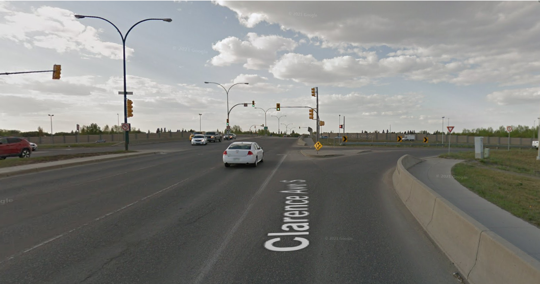
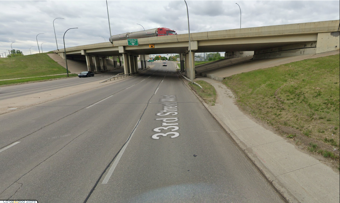
What will the sidewalks at Clancy Drive and Laurier Drive look like?

The Laurier Drive interchange will include sidewalks beside travel lanes on one side.  It would look similar to Clarence Avenue over Circle Drive: 

Clarence Avenue and Circle Drive

The Clancy Drive interchange will include sidewalks beside travel lanes on one side.  It would look similar to 33rd Street under Circle Drive:

33rd Street and Circle Drive

Pedestrian Connections across 22nd Street:

Where would pedestrians and cyclists cross 22nd St to get from Confederation Mall to the Tim Horton’s on Fairlight Drive (north business area to south business area)?

People can cross 22nd St at the Diefenbaker Drive intersection or use the pedestrian overpass near the CN Rail tracks that will remain in place. 

A pedestrian crossing has been included on the west leg of the intersection of Confederation Drive and 22nd Street to accommodate crossing between the two business areas. 

 Is the pedestrian overpass crossing 22nd Street just east of Circle Drive West going to remain in place?

Yes, this pedestrian structure is not affected by this plan.

Traffic Noise Sound Attenuation:

Will there be sound attenuation walls added or improved along Circle Drive within the project’s limits?

A traffic noise sound attenuation study was completed as part of this project and found that traffic noise levels along the new Circle Drive alignment will not exceed the bylaw at the 500,000 population horizon.  Therefore, no traffic noise sound attenuation measures have been recommended.

Laurier Drive Traffic Movements:

Why hasn’t a southbound exit been included at Laurier Drive?  This does not retain the same functionality that already exists and may cause traffic issues in the neighbourhood.

There is not enough room for a Laurier Drive southbound exit, due the proximity of the 22nd Street interchange. Circle Drive exiting traffic and the Laurier Drive entering traffic would not have enough time or opportunity to weave between lanes at high-speed through the area to get to their destinations.

What happens to vehicles that currently go through Laurier Drive to south Circle Drive?

With the proposed plan, vehicles that currently take Laurier Dr to southbound Circle Dr could go westbound on Laurier Dr to Confederation Dr, then and then eastbound on 22nd St to the Circle Dr southbound ramp.

  • Approximately 350 vehicles currently make the eastbound right turn movement from Laurier Drive onto southbound Circle Drive in both the AM and PM peak hours.
  • Approximately 150 vehicles in the AM peak hour and 250 vehicles in the PM peak hour currently make the left turn movement from Circle Drive northbound to Laurier Drive westbound.

Will removing the movements to and from the south on Laurier Drive increase traffic at Diefenbaker Drive and 22nd Street significantly?

Our traffic modeling predicts that re-directing traffic from Laurier Dr to Diefenbaker Dr for access to 22nd St will increase traffic at that area; however, it will still be within the capacity of the network. Some vehicles will take other routes.

Speed Limits:

Will speed limits increase on Circle Drive between 33rd Street and Clancy Drive once this change is completed?

Yes, the speed limit on Circle Dr between 33rd Street and Clancy Drive will increase to 90 kilometers per hour.

Diefenbaker Drive:

Why isn’t an upgrade of the Diefenbaker Drive and 22nd Street intersection included in the plan?  The changes proposed will make the intersection a lot busier.

An assessment of Diefenbaker Drive was outside of the scope of this project.  The focus of this project is the long-term plan for Circle Drive; however, an assessment and possible upgrades may be required in the future. As more development in Saskatoon’s west and the Bus Rapid Transit (BRT) system is implemented, 22nd St will be widened further west.  Once the recommended plan for Circle Drive has been finalized, additional work can be completed to determine the required upgrades to 22nd Street in coordination with BRT, future growth planning and this plan. 

Will upgrades to Diefenbaker Drive be implemented at the same time as these other recommendations if it is not included in this plan?

The Circle Drive West Functional Plan still needs to be finalized and funded, so no work is schedule to implement this long-term plan. Upgrades to Diefenbaker Drive may be coordinated with other upgrades along 22nd Street, either in anticipation of the Circle Drive West Functional Planning Study, or as part of other area projects like the Bus Rapid Transit plans.

11th Street Access:

Why can’t the current 11th St exit from Circle Drive southbound be maintained in this plan?

Circle Drive is proposed to become a free flow facility rather than including a traffic signal at Clancy Dr.  This existing traffic signal separates the movements to Clancy Dr and the 11th St ramp.  The southbound entering movement (to Circle Dr) from Clancy Drive cannot occur safely at the same time as the southbound exiting movement to 11th Street over such a short distance once traffic is operating in free flow on Circle Drive.

How many trains block the 11th Street crossing versus the Dundonald Ramp crossing?

Train crossing data was determined using rail crossing times and occurrences based on information retrieved from the City’s Rail Notification Systems.  Two sets of data were retrieved: one from December 2021, and one from May 2022.  The following information was determined:

Location

Blockages per week

December 2021

Average Duration

December 2021

Blockages per week

May 2022

Average Duration

May 2022

11th Street

82

6:04 minutes

61

5:33 minutes

Dundonald Ramp

49

Unknown

31

3:46 minutes

From this data we can see that the 11th Street crossing is blocked more frequently and for longer on average than the Dundonald Ramp crossing.

The southbound Circle Drive access to 11th Street serves eastbound traffic to Meadowgreen, West Industrial, and Holiday Park neighbourhoods and westbound traffic to Montgomery Place, Fairhaven, and Parkridge.  Existing traffic information shows that half or more traffic is wishing to travel eastbound.  Eastbound traffic would not cross any rail tracks under the new loop ramp configuration.

What will the intersection at the new Circle Drive exit to 11th Street using the loop ramp look like?  Will there be capacity to hold enough vehicles on that ramp if trains are blocking 11th Street?  I’m concerned that it may back up onto Circle Drive creating safety issues.

In the proposed plan, the intersection at 11th Street will be a typical signalized intersection.  The exit ramp from Circle Drive is designed as a generous loop, taking into account current and future traffic demands.

A 1,610m long train travelling at 20kph during the PM peak hour was evaluated.  It was determined that a 70m long queue may occur.  The loop length is adequate to store the possible queue resulting from the average train.

Why doesn’t this plan include a road passing over or under the rail line on 11th Street?  Trains are a big issue for access to the Montgomery Place neighbourhood.  The new 11th Street access location will require westbound traffic to cross the main rail tracks leading to Chappell Yards and the wait times can be long.

The Circle Drive West Functional Planning Study does not include the Rail Grade Separation at 11th Street (PDF).  Find more information in the Rail Relocation versus Grade Separation Feasibility Study - January 2021 Update report that went forward to City Council where it was placed on the Infrastructure Priority List in the Saskatoon Transportation Master Plan. 

The new 11th Street exit ramp from Circle Drive will be a loop ramp which is a conventional interchange design recommendation. Both this Circle Drive West Functional Plan and the 11th Street Rail Grade Separation Project (routing traffic over the rail line) are future long-term projects. Neither of these projects have a timeline attached to them for implementation.

If a train on the north/south CN Rail track is blocking 11th Street and another train on the CP Rail track is blocking the crossing at Fairlight Drive and Elevator Road, how will emergency vehicles access Montgomery Place?

Trains at these intersections can be problematic for traffic and emergency vehicles. However, emergency services would coordinate their response in a similar fashion as they do today.

It is not likely that both the north/south and east/west tracks would be blocked simultaneously.  Saskatoon Fire has indicated that in a two-engine response, engines could take two different routes and be confident that at least one would not be blocked by a train.

What is the timeline for building the 11th Street grade separation?

There is currently no timeline for the implementation of this project.  The project is included on the Infrastructure Priority List in the Saskatoon Transportation Master Plan. The infrastructure priority list is updated at minimum every five years and includes all transportation projects city-wide.

Have other rail grade separated options to access Montgomery Place been considered, such as an off-ramp and on-ramp between Circle Drive southbound and Dundonald Ave through the proposed solar farm location?

Any rail grade separation at 11th Street was outside of the scope of this project.  A Rail Relocation versus Grade Separation Feasibility Study - January 2021 Update report went forward to City Council where it was placed on the Infrastructure Priority List in the Saskatoon Transportation Master Plan.  The first phase of this study was presented in March 2018: Rail Relocation versus Grade Separation feasibility Study – Phase 1 report.

Other Locations within the Study Area:

Why is the ramp over Confederation drive being removed for the movement exiting Circle Drive southbound onto 22nd Street West?  Trucks will now have to travel through the 22nd Street and Confederation Drive intersections.  Won’t this make things more difficult for trucks?

Yes, the ramp that currently takes you from Circle Drive southbound to 22nd Street westbound is removed in this configuration.  Part of the reason is that 22nd Street will be three lanes wide, plus additional turning lanes.  If that ramp were to be retained, drivers could not safely maneuver to make a left turn at Diefenbaker Drive through the additional lanes (this does happen today, but can be challenging at certain times – for both safety and opportunity).  Truck traffic will be required to travel through the intersection of Confederation Drive when making this movement.

Why not allow access from Fairlight Drive to the 22nd Street off ramp to Circle Drive South?

It’s not best practice under Transportation national guidelines to connect a local access road to a freeway.  Fairlight Drive traffic will take Fairmont Dr southbound and connect to Circle Drive southbound at Clancy Drive.

How will westbound traffic on 22nd St access Parkridge and Fairhaven neighbourhoods?

From 22nd St westbound, drivers will turn left at Diefenbaker Dr intersection to access Parkridge and Fairhaven neighbourhoods at Fairmont Dr.

What is the consideration for truck traffic southbound on Circle Drive?

There is a bypass ramp proposed for truck traffic entering Circle Drive south from 22nd Street eastbound.  Trucks will be able to bypass the Confederation Drive and Circle Drive intersections to access Circle Drive southbound.

Is Clancy Drive exit going to be an underpass?

Yes, Clancy Drive will access Circle Drive via an underpass.

Has there been any thought to allow vehicle access between Fairhaven and Meadow Green at Clancy Drive and 18th Street West under the CN Rail tracks?

No. This connection was not included in the scope of this project.  This plan was focused on Circle Drive and its operations at Clancy Drive and Laurier Drive.

Was any consideration given to people who travel between west-end areas like Parkridge, Fairhaven, and Pacific Heights and downtown, particularly during peak traffic times?

Yes.  The Consultant reviewed the City’s current traffic model in these areas and reassigned those trips in the analysis to evaluate 22nd Street and Circle Drive. The effectiveness of the proposed transportation plan is based on the reassigned volumes. 

Will it take longer to get from Laurier Drive to Circle Drive southbound once the proposed changes are implemented?

The new route is about the same timing, from Laurier Drive to Circle Drive southbound is via Confederation Drive southbound under 22nd St to the re-aligned Circle Dr S on-ramp.

A trip from Cosmo Civic Centre to a point just south of Clancy Drive on Circle Drive southbound is expected to take approximately 2:24 minutes.

General Questions and Comments:

Will public feedback from the third Open House be considered before the final plan goes forward to the Standing Policy Committee on Transportation (SPCT)?

Yes. All new comments and feedback will be incorporated to help draft the report to the SPCT, which is planned for Winter 2022/2023.

Are there additional images and animations to help residents understand the plans?

Yes. The presentation from the October 2021 Open House 3 is available and includes many additional images that help describe the changes proposed.  Animations were not produced as a part of this project.

How will residents in Parkridge and Fairhaven be impacted during construction?

There is still more work to finalize and get approval, then funding the project before the construction phasing and detour plans are designed.  Those plans would be developed closer to the time of construction and always consider local traffic access.

How much will this project cost to build?

The third open house completed the public engagement portion of the Circle Drive West Functional Planning Study.  The next steps are completing the engineering of the recommended plan, including noise modelling and mitigation, and developing a cost estimate.

How long will this take to build?

Construction of this project is not yet scheduled.  It is also unknown how long construction could take.

Can you please post the proposed interchange plans for the 11th Street rail grade separation?

Yes: Proposed grade separation plans for 11th Street (PDF). Information on the grade separation can also be found in the Rail Relocation versus Grade Separation Feasibility Study - January 2021 Update report that went forward to City Council where it was placed on the Infrastructure Priority List in the Saskatoon Transportation Master Plan. 

Can construction of an eastbound turn bay on 22nd Street happen sooner to accommodate existing traffic wanting to turn onto Circle Drive?

Once the long-term Circle Drive West Functional Project is finalized and adopted by City Council, the City will have a road map to start making smart investments in infrastructure over time as required for improving current operations.

Can construction of dual left turn lanes from the Circle Drive northbound exit onto 22nd Street be accelerated?  The future plan looks like an improvement, but it sounds like construction is a long time in the future.

The ultimate phasing of the construction of this plan has not been finalized. That being said, due to the substantial change this plan proposes for the Circle Drive northbound exit onto 22nd Street, it is not likely that this portion alone will be able to be accelerated.  Opportunities to make improvements to the existing exit to allow for dual left turn movements here are being evaluated.  Completion of this project, and adoption of the recommended plan, will allow us to make good investments in current infrastructure projects.

This plan is horrible with only one access point to get into some neighbourhoods.

The number of access points to all affected neighbourhoods is the same; however, the particular patterns for access will change.

Has Saskatoon Transit been consulted regarding this plan?

Yes. The Saskatoon Transit and Bus Rapid Transit planning teams have been included as stakeholders throughout the development of this proposed plan.

Can additional pedestrian crossings be implemented around the 11th Street and Dundonald Avenue intersection?  Lots of children are crossing here before and after school.

Thank you for this comment.  It was shared with the appropriate staff within the Transportation Engineering department for review under the correct program. This work is outside of the scope of this project.

This work will result in many detours to various areas and effect traffic, emergency vehicles, and businesses.  How will the city minimize the effects during construction?

There is still more work to finalize and get approval, then funding the project before the construction phasing and detour plans are designed.  A construction management and detours plan will be established as a part of the detailed design and construction plan closer to the time of construction and always consider local traffic access.

Emergency Response:

Does the current plan ensure compliance of NFPA 1710, fire protection into Montgomery Place?  What impact will the changes have on our emergency responders’ ability to respond to calls?

Fire and Protective Services are a stakeholder on this project and all large-scale transportation projects.  Additionally, this project cannot be viewed in isolation.  It needs to be considered alongside the 11th Street grade separation plans.  Fire and Protective Services will have a say in implementation to ensure they can respond effectively.

Do you consult with 911 emergency services during this process?

Yes.

What comments have emergency services made regarding the changed access to Montgomery Place from Circle Drive southbound?

Fire and Protective Services has response plans for the Montgomery Place neighbourhood that include consideration for the possibility of train conflicts.  Consultation with Fire regarding these plans indicated that the relocation of the 11th Street ramp is not expected to adversely affect their response and may be an improvement overall.

Other Areas:

When will you tackle the issues at Circle Drive and Avenue C? 

This project is high on the Infrastructure Priority List in the Saskatoon Transportation Master Plan; however, there is no funding or timeline identified yet. 

Is there a recommendation for a rail grade separation for 33rd Street immediately east of Circle Drive to help accommodate the added traffic from newly developed neighbourhoods to the west?

No.  This location was included in the Rail Relocation versus Grade Separation Feasibility Study - January 2021 Update report and was not recommended for future study.

Confederation Drive between 22nd Street and 33rd Street is very busy already, making it tough to get out of the Massey Place neighbourhood.  How will this plan address this issue?

While Confederation Drive north of 22nd Street was not included in the scope of this project, we heard this concern during the Massey Place Neighbourhood Traffic Review (NTR).

Based on the analysis completed in the NTR, the following recommendations were made for Confederation Drive. These recommendations should resolve access issues for the Massey Place neighbourhood.

  • Install traffic signals at Confederation Drive and Milton Street - awaiting funding; and
  • Confederation Drive and Massey Drive Active Pedestrian Corridor - completed. 

Contact Us

Transportation
Email Us

Timeline

  • June 19, 2019

    Open House #1
  • Summer/Fall 2019

    Develop Options
  • January 22, 2020

    Open House #2
  • Spring/Summer 2020

    Revise preferred plan
  • October 21, 2021

    Online Public Information Meeting
  • November 9, 2022

    Present the plan to Standing Policy Committee on Transportation
  • November 21, 2022

    City Council approves the Recommended Plan

Related Documents

Circle Drive West - Study Area Map1.27 MB
Circle Drive West - Open House #1 Public Engagement Report165.45 KB
Circle Drive West – Open House #2 Public Engagement Report193.82 KB
Circle Drive West - Open House #3 Preferred Plan6.61 MB
Circle Drive West - Open House #3 Public Engagement Report266.18 KB

Related Pages

November 21, 2022 City Council Meeting (item 8.2.4)

Connect With Us Online

Visit Contact Page

  • Twitter
  • Facebook
  • YouTube
  • Instagram
  • Linkedin

City Hall

222 3rd Ave North
Saskatoon, SK
Canada
S7K 0J5

Hours
Mon - Fri: 8am - 5pm
Sat - Sun: Closed
Stat Holidays: Closed

Phone Us

Service Saskatoon
Customer Care Centre

Available 24/7
306-975-2476

Inquiries: Utilities, Property Taxes, and Parking
Mon-Fri: 8:30am - 5pm
306-975-2400

Saskatoon Light & Power
Available 24/7
306-975-2414

Saskatoon Police
306-975-8300

Saskatoon Transit
306-975-3100

Can't find the number you are looking for?
Try our directory

Quick Links

  • News Releases
  • Events
  • Service Alerts
  • Interactive Maps

Home

© Copyright 2025 City of Saskatoon

  • Privacy Statement
  • MyCity