Engage - Neighbourhood Concept Plan Amendment
Proposal
The Planning and Development Department has received a Neighbourhood Concept Plan Amendment and associated land use applications from Catteral & Wright on behalf of Victory Majors Development proposing to amend the Eastern portion of the Aspen Ridge Neighbourhood Concept Plan (Concept Plan).
A Neighbourhood Concept Plan is a neighborhood-level land use plan that guides the development of a new neighbourhood in Saskatoon. It outlines the land uses, densities, transportation network, parks system, and community facilities intended for a neighbourhood as it grows.
Proposed Amendment Summary
The submitted application has proposed the following changes:
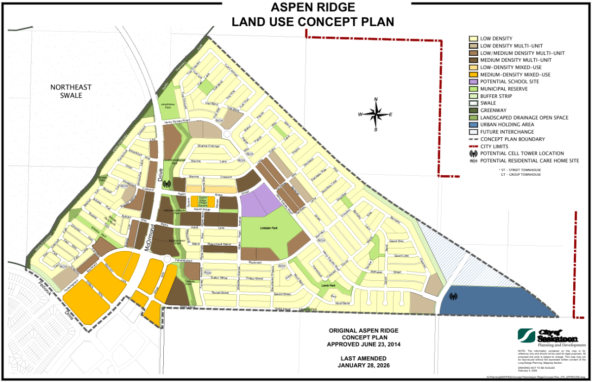
Saskatoon Freeway Overlay: City Council endorsed a new alignment for the Saskatoon Freeway on March 27, 2024 which is not adjacent to the NCP area. The Saskatoon Freeway Overlay has been proposed to be removed from the NCP land use map.
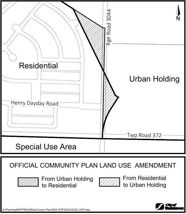
Change of Land Use: This amendment includes removal of the buffer strip parcel along the northeast boundary of Aspen Ridge. This buffer strip was initially designed to separate residential parcels from the previous Saskatoon Freeway alignment. The buffer zone will be replaced by additional low-density residential development. The Urban Holding Area has been removed.
Change of Land Use: Land uses in the eastern portions of the NCP will be adjusted due to the removal of the “Future Interchange” hatched area and its adjacent buffer. This area is replaced by additional low density residential land uses.
Neighbourhood Boundary Adjustment: The eastern edge Aspen Ridge neighbourhood boundary will be adjusted due to the removal of parcels owned by Cindercrete Products Limited from the NCP. The following two parcels are being removed from the NCP and will become the eastern boundary of the neighbourhood concept area:
• LSD 4- 16-37-04-3 Ext 31
• LSD 5- 16-37-04-3 Ext 32
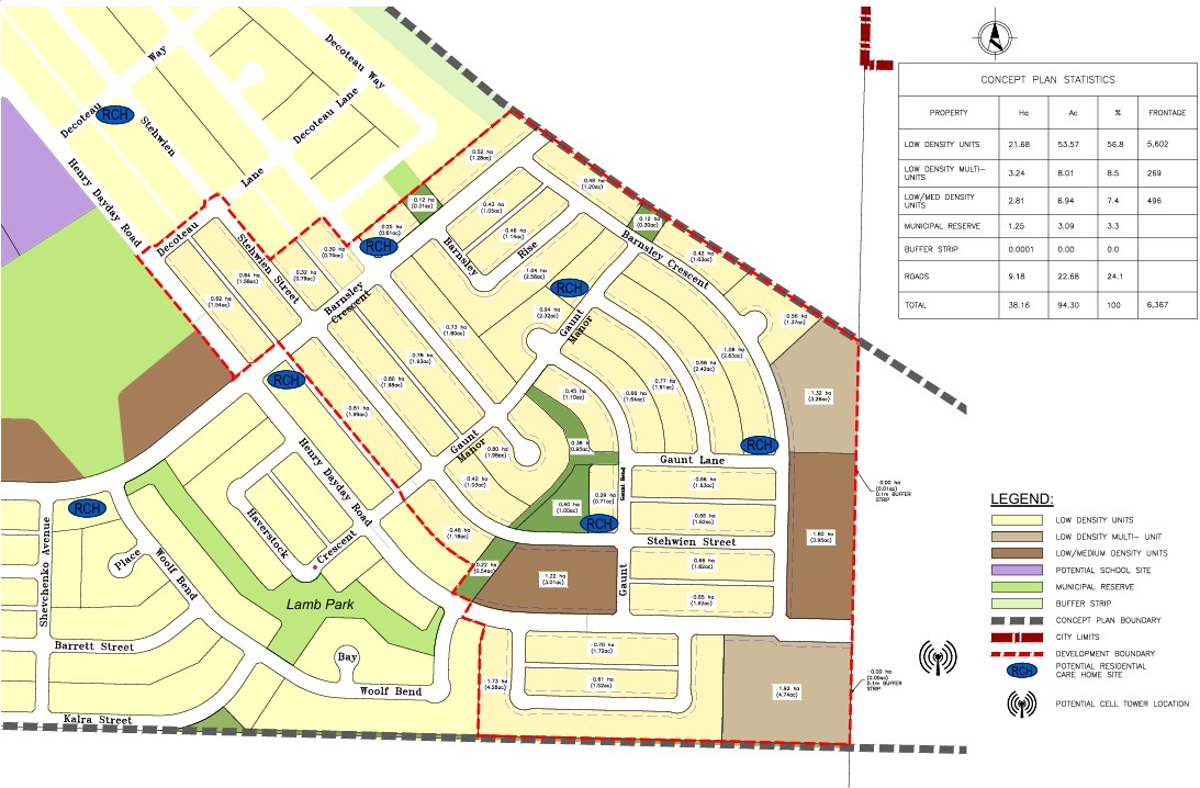
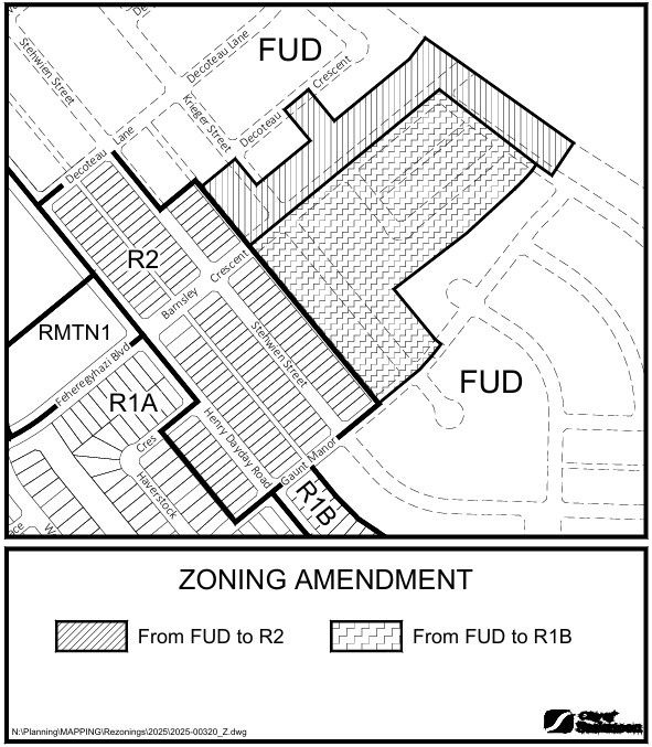
Change of Land Use and Road Network Configuration: Change the land use and road network throughout the amendment area. The overall road layout, municipal reserve configuration, and residential development areas have been adjusted based on the updated neighbourhood boundary. The resulting municipal reserve area has been adjusted due to the change in total neighbourhood area. Low/Medium Density land use was added to the concept.
Road Network Reconfiguration: Reconfiguration of the residential road network south of Henry Dayday Road to replace three cul-de-sacs with one crescent.
Potential Cell Tower Relocation: The potential cell tower located in the future “Urban Holding Area” has been relocated since this area is no longer included in NCP.
2026 Amendment: Aspen Ridge NCP Amendment approved on Wednesday, January 28th, 2026, was included in the Concept Plan existing Statistics Table.
Barnsley Crescent: Barnsley Crescent will provide for future connection to the north and be a collector road.
Programmable Park Space: The proposed concept’s central park contains 1 acre of programmable park space.
Current Approved Concept Plan
Proposed Concept Plan Amendment