The Project
College Corridor Plan passed by City Council
November 19,2025
Find the agenda and report here. You can also click on the image below to view the Plan in its entirety.
Image:
November 19,2025
Find the agenda and report here. You can also click on the image below to view the Plan in its entirety.
The Corridor Planning Program is the City of Saskatoon's approach to guiding growth and development along the planned Link (rapid transit) routes, within the Corridor Growth Area. This work is grounded in long-term City policy, including the Official Community Plan (2020), Corridor Transformation Plan (2020) and the Growth Plan to Half a Million (2016), which aim for 15 per cent growth to occur in this area. To help achieve this goal, the Corridor Growth Area has been divided into ten plan areas, with a Corridor Plan being developed for each. These plans provide a framework for land use, zoning, infrastructure and public realm improvements, and are supported by specialized corridor zoning districts to guide redevelopment near rapid transit. Rooted in community engagement, research and policy alignment, the Corridor Planning Program aims to meet the needs of both current and future residents while supporting a more compact, connected and sustainable city.
Where previous plans exist within the Plan Area, efforts have been made to align with their direction. However, this Plan reflects updated land use, zoning and improvement strategies based on current policy and community input. It is intended as an update rather than a replacement, but where conflicts arise, this Plan supersedes.
The interactive map linked below shows the College Corridor Plan study area, as well as the other corridor plan areas across Saskatoon that will be the subject of future corridor plans.
Launch Interactive Corridor Growth Area Map
The vision aims to transform the College Corridor into a thriving, people-friendly space with a safe and inviting streetscape that encourages walking, cycling and high-frequency transit use. The Plan emphasizes mixed-use development that integrates residential, commercial, institutional and community amenities, while supporting the City's goal of promoting growth along major corridors.
The project team has completed a report on existing or ‘baseline’ conditions of the College Corridor as an initial step in the process to develop the College Corridor Plan. This document summarizes existing conditions and characteristics related to the area’s history, contemporary plans, demographics, current land use, transportation and mobility, housing and neighbourhoods, parks, trails and open space, and recreation and community facilities.
College Corridor Plan Background Report
The Saskatoon Heritage Society also compiled a report on properties of interest in the area. This inventory can be found here and will be referenced when considering aspects regarding land use and public realm as part of the College Corridor Plan.
Corridor Planning Engagement Strategy
The purpose of the Corridor Planning Engagement Strategy is to outline the City’s goals and processes for working with community members throughout the Corridor Planning Program. It was created by talking with a variety of representative stakeholders and partners in spring 2021. More details on the feedback received, and how it informed this strategy and the Corridor Planning process, can be found in in the Corridor Planning Preliminary Engagement Summary and Preliminary Engagement Report.
For a full overview of the Corridor Planning Program please visit the Corridor Planning Program project page. Our work is guided by the Corridor Transformation Plan endorsed by City Council in 2020.
We have created a dedicated playlist on YouTube that will host all our previous presentations so you can review all the background information to date in one convenient place.
As part of the Corridor Planning Program, a pre-engagement process was carried out to identify interested parties and preferred methods of engagement. Public engagement for the College Corridor Plan took place between September 2021 and September 2023, covering topics such as land use, public realm and zoning. A variety of engagement methods, including online surveys, interviews, workshops, pop-up events and interactive mapping, were used to gather broad and inclusive input. Feedback was documented in detailed engagement reports and incorporated into the final plan to reflect public priorities.
Please see the sections below for presentations and documents that were shared during each stage of this project.
September 2021 marked the public launch of the College Corridor Plan with an introductory public information meeting and survey.
The team presented background information on the College Corridor Area and asked the community about opportunities and challenges. A baseline conditions report and heritage inventory is available on the Background tab. The recording of the meeting is available below:
For full details, please see the College Corridor Plan Introductory Phase Engagement Report.
Land use refers to the types of homes, businesses and other buildings that can be built in an area. When land uses are determined, it does not mean that buildings will automatically be built. It is property owners who decide what to do with their land – whether to keep it as it is, or to develop something new.
Land uses are set out in a general way through the Official Community Plan (OCP) – the legal document that lays out the collective long-term vision for Saskatoon. While land uses can be applied to parcels of land in order to accommodate future development, they do not strictly regulate the development that may or may not occur; this is the role of zoning.
College Corridor Plan Land Use Engagement Report
The team hosted a come-and-go event in September 2023 to discuss changes to land use and zoning for the College Corridor area, and considered how the Corridor Zoning District regulations align with the vision for the College Corridor Plan area.
The display boards are provided below. Please note that some of the information presented is now outdated.
College Corridor Plan Information Session Sept 20 2023 - Display Boards
Please refer to the Corridor Land Use and Rezoning page for the approved land use plan for the College Corridor Plan Area, approved by City Council in June 2024.
On November 3 & 4, the project team discussed the concept of land use and presented preliminary ideas on land use and density changes for the College Corridor area.
The team then used community input and technical planning considerations to create different land use scenarios, which were presented in a meeting on November 24 and survey for public feedback to develop a more detailed land use concept.
Public realm refers to the publicly accessible places and spaces that are intended to be accessed by everyone. Public realm includes an area’s streetscape - including sidewalks, pathways, boulevards and the look and feel of the streets - as well as open space - including green spaces, parks and recreation uses.
In 2022, the team conducted two rounds of engagement and gathered valuable input from the community on improving the public realm within the College Corridor Plan area. Through a number of workshops, meetings and surveys we have gained a better understanding of the public's preferences on open space locations and streetscape improvements. We used the feedback from the first round of engagement to inform the second round, which involved priority surveys. This information will be used to help us create a plan that meets the needs of the community and supports the overall vision for the development of the area.
College Corridor Plan Public Realm Engagement Report
In spring 2022, the team worked with stakeholders, community groups, people who live, work, study or visit the College Corridor area and interested people from around Saskatoon to help determine what is important to people about the public realm on College Drive and Preston Avenue – what it looks like now and what it could potentially look like in the future. The team hosted a series of virtual public meetings and surveys on different public realm topics.
This meeting focused on existing open spaces and possible new open spaces in the area, such as parks, outdoor plazas, sports fields or other open spaces where people can relax and gather. Presentations:
This meeting focused on the connections to, and along, the College Drive and Preston Avenue corridors for people walking and rolling (e.g. cycling, wheeling, mobility aids, etc.) - and the infrastructure that may be needed to support this. Presentations:
This meeting focused on things that affect how College Drive and Preston Avenue look and feel, such as the design of the front of buildings, street furniture and amenities like benches, and styles or themes that could be incorporated into the design of the streetscape. Presentations:
Public realm input from spring 2022 was shared with the community via a video presentation on YouTube.
Feedback themes pertaining to different locations in the study area were also presented in the map below. (Click on the map to see the full size version.)
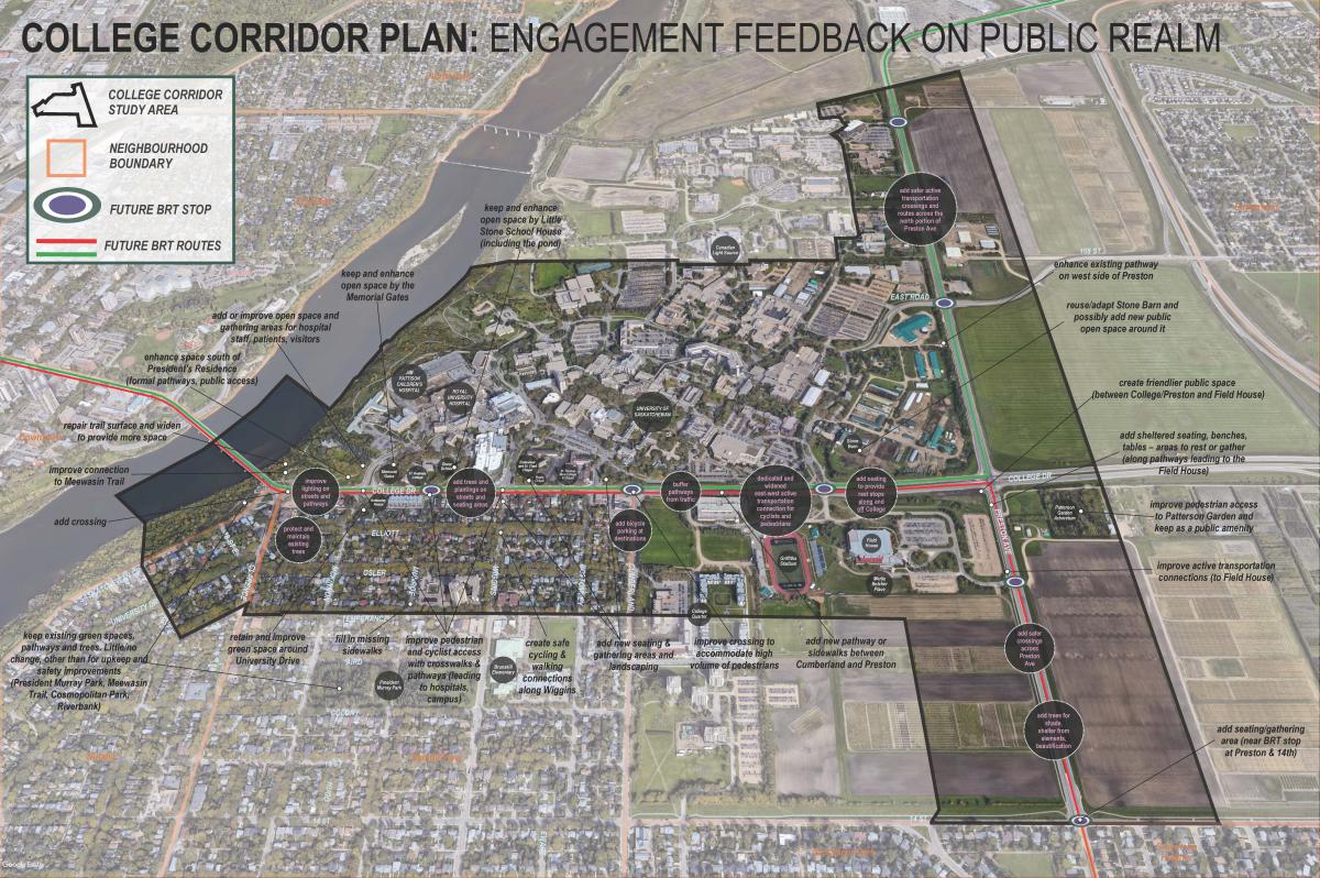
We used the earlier public realm feedback to develop a list of potential open space and streetscape improvements for the College Corridor area. Surveys in fall 2022 asked community members to identify their priorities and preferences for where resources should be focused when the team develops the plan for public realm improvements. A hybrid in-person/virtual guided walkthrough event for these surveys was held on November 21.
Please see our public realm engagement summary and the video presentation above on the community feedback we received.
Land Use
The land use engagement process involved two rounds of online meetings and surveys to gather community feedback on land use and density changes. Input from these sessions, as well as technical analysis, shaped a preliminary land use map in 2021 that supported higher density along College and Cumberland Avenue. In November 2023, the land use map was revised to align with the City’s Housing Accelerator Fund (HAF) commitments, departmental feedback and engagement insights. The updated land use map was presented in an online session in February 2024.
Public Realm
Input was gathered on walking and rolling connections, streetscape elements, open spaces and design themes that reflect the area’s character. Feedback helped identify opportunities and challenges, leading to a list of potential improvements. In Fall 2022, participants prioritized locations and shared preferences for streetscape features, heritage elements and open space enhancements. These insights, along with technical consideration and space constraints, guided the Plan.
Zoning
Engagement focused on potential area-specific amendments to the corridor zoning districts to accommodate the unique contexts of the Plan area. Feedback supported amending the Corridor Station Mixed-Use 1 (CS1) zoning to remove commercial requirements for the ground floor and to permit development on smaller sites with a reduced height.
Thank you for your patience as we prepared the first Corridor Plan. The process was paused while we completed land use plans for six plan areas. While this has taken longer than originally expected, it allowed us to provide input into the Link design by sharing feedback gathered during earlier consultations. In the meantime, some actions have already moved forward, including the adoption of the land use plan and the start of the opt-in rezoning process.
We’re excited to share the full Corridor Plan with the community and will be hosting an information session in early October. Stay tuned for more details!