
46th Street Storm Sewer Project
On June 24th, 2026, City Council approved City Administration to proceed with designing and constructing a new storm sewer pipe to reduce flood risk for properties near the 46th Street East and 1st Avenue North intersection. This area has a history of significant flooding and is expected to experience future flooding with climate change.
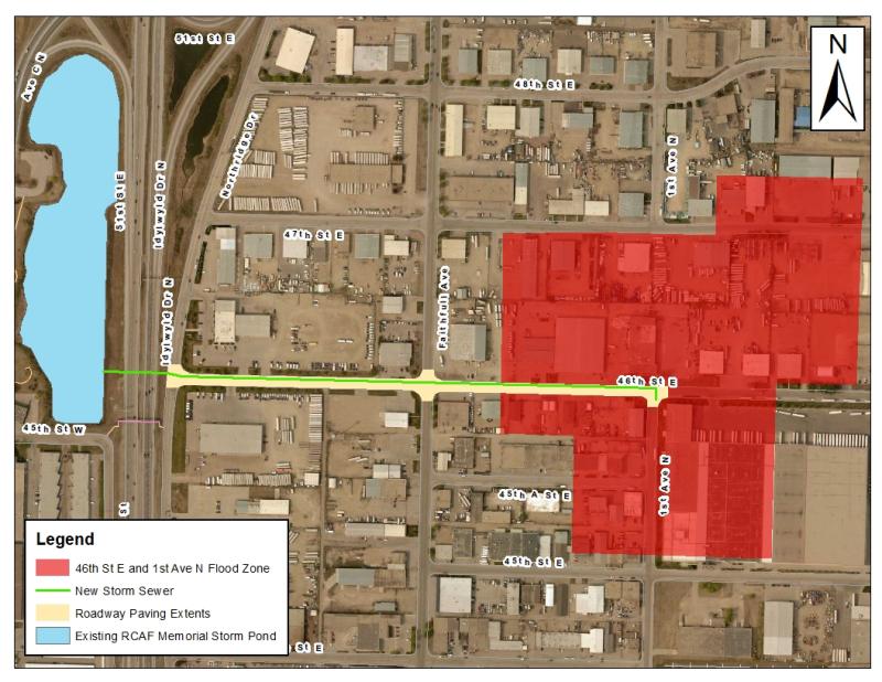
The scope of the proposed project includes the installation of a new 1500mm storm water pipe along 46th Street East, from 1st Avenue North to the storm pond in RCAF Memorial Park. As part of the project, the existing storm pond will be cleaned out to remove built-up sediment to increase its storage capacity and ensure effective operation of the new storm infrastructure to the pond.
The image below indicates the location of the proposed storm sewer pipe installation.
Why is there such a high risk of flooding in this area?
Flooding only occurs during significant rain events. Neighborhoods developed prior to 1989 were not constructed to the same design standards and storage requirements in place today. Significant rain events are now managed through wet and dry ponds, which have the ability to collect high volumes of storm water.
While there is an existing storm pond in RCAF Memorial Park located near the 46th Street East and 1st Avenue North intersection, this area was not designed to and does not currently drain into the storm pond.
How will this project impact the risk of flooding in the area?
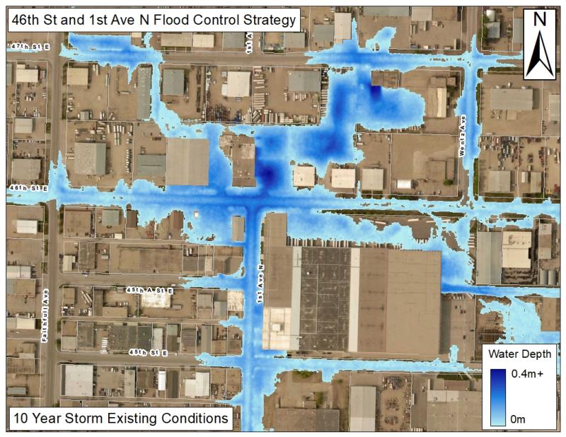
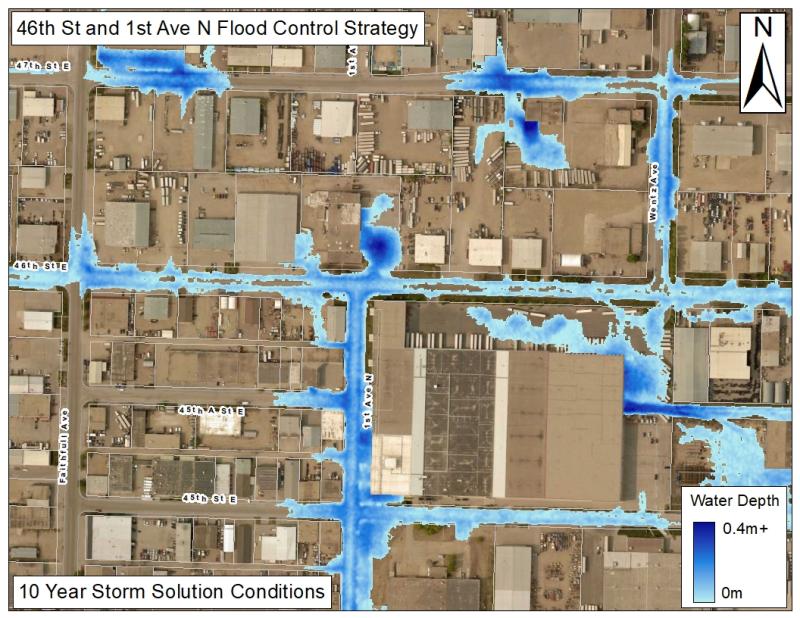
The new proposed storm sewer will reduce flooding at up to 5 properties in a 1-in-10-year storm, or up to 10 properties on an annual basis near the intersection of 46th Street & 1st Avenue. Instead of storm water ponding on the street and possibly entering nearby buildings, the storm water is proposed to be transported to the existing RCAF Memorial Storm Pond to mitigate flooding in the area. The map below displays flood risk in the area under current condition in the event of a 1 in 10-year storm, followed by a map displaying flood risk during a 1 in 10-year storm once the new storm infrastructure is in place.
How will the nearby area be impacted?
Roadways will be closed during construction. Closures will be phased to minimize disruption to traffic and businesses as much as possible. Access to businesses will be maintained at all times throughout construction. If applicable, alleys and alternative accesses may be utilized. Additionally, there is expected to be some traffic disruptions to Idylwyld Drive to accommodate construction. Further details and timelines will be shared in the coming months as the detailed design is progressed.
When will construction occur?
The proposed timeline for this project is as follows:
- Sediment dredging in RCAF Memorial Park Storm Pond: February – March 2027
- Installation of new storm sewer infrastructure: May – October 2027
- Construction Completion: Fall 2027
What areas will be impacted by construction?
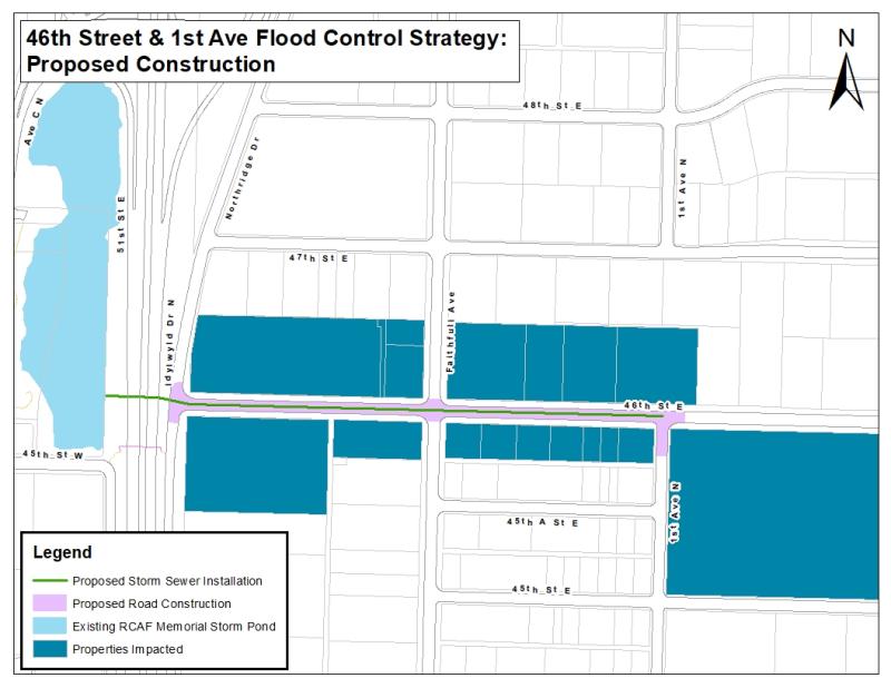
Below is a map displaying the construction areas.
Will trees be impacted by the project?
No trees are currently planned to be impacted by the project. If the detailed design requires this to change such that removals are required, the project will provide necessary compensation for tree removal, as outlined in City Council Policy C09-011 Trees on City Property.
What is the Flood Control Strategy?
If you’ve ever experienced flood damage, you know how devastating it can be. Though parts of Saskatoon have always been susceptible to flooding, and flood protection measures to date have helped, climate change is expected to bring more frequent and intense storms.
In December 2018, the City Council approved implementation of the nine-year, $54 million Flood Control Strategy to mitigate flooding in ten areas that experience frequent flooding. 46th Street & 1st Avenue is the ninth area receiving upgrades as part of this Strategy. Visit the Flood Control Strategy page for more information.
How is the project being funded?
In 2019, the Government of Canada approved 40% cost sharing of the Flood Control Strategy’s total estimated eligible expense of $54.1 million, up to a maximum of $21.6 million through the Disaster Mitigation and Adaption Fund. The City approved Storm Water Utility funding of 32.4 million through previously approved increases to the Storm Water Management Charge to cover the other 60% of the expenses. The City’s Storm Water Utility will fund any cost overage of the FCS through capital reserve allocation if required.
The 46th Street & 1st Avenue project is estimated to cost $8.7 million with the City contributing 60% ($5.2 million) and the Government through the Disaster Mitigation Adaption fund contributing 40% ($3.5 million)